Travellers through Port Wakefield asked to plan ahead this Easter long weekend
Wednesday 13 April 2022
Holidaymakers travelling through Port Wakefield over the coming long weekends are being asked to be patient and plan ahead for their journeys, as major project works continue.
Works are continuing on both the $124.5 million Port Wakefield Overpass and Highway Duplication and $260 million Augusta Highway Duplication projects, which are jointly funded by the Australian and South Australian governments (80:20).
These projects will ensure safer, smoother and faster journeys for travellers to and from Yorke Peninsula and the north of the State.
The new Copper Coast Overpass, which opened to traffic in December 2021, has removed all at-grade hazardous turn movements at the intersection of the Port Wakefield Highway, Copper Coast Highway and Augusta Highway, making it safer for road users especially during peak holiday periods.
Motorists should allow extra travel time during the upcoming Easter and Anzac Day long weekends (15-18 April 2022 and 23-25 April 2022) and school holidays.
To assist the significant number of visitors through Port Wakefield during the upcoming long weekends and school holidays, some traffic restrictions associated with the works were temporarily lifted from 6am this morning (Wednesday, 13 April 2022). This includes two lanes being open to traffic for southbound motorists, from south of the Wakefield River Bridge to Shrike Road, to help reduce delays.
Speed restrictions will remain in place through the continuing works, which are occurring on the Port Wakefield Highway, within and just north of Port Wakefield, and on the Augusta Highway, north of the new Copper Coast Overpass.
North of the township, northbound and southbound traffic will continue to travel one lane in each direction via the Wakefield River Bridge. The new northbound Wakefield River Bridge is expected to be complete in October 2022. Northbound traffic through the township also remains reduced to one lane at all times as works continue.
Please plan ahead and allow extra travel time as delays may be experienced during this period, and until project completion.
Please take extra care when workers are on site. Observe speed limits, lane restrictions and traffic controllers when travelling through the area. Signage will be in place to alert motorists to the changed traffic conditions.
The Department thanks motorists for their patience and cooperation while these important works are undertaken.
The Port Wakefield Overpass and Highway Duplication and Augusta Highway Duplication projects are being delivered by the Port Wakefield to Port Augusta (PW2PA) Alliance.
For more information about both projects, please visit the PW2PA Alliance website.
More information about the temporary traffic arrangements in place on Port Wakefield Highway from Wednesday, 13 April 2022:
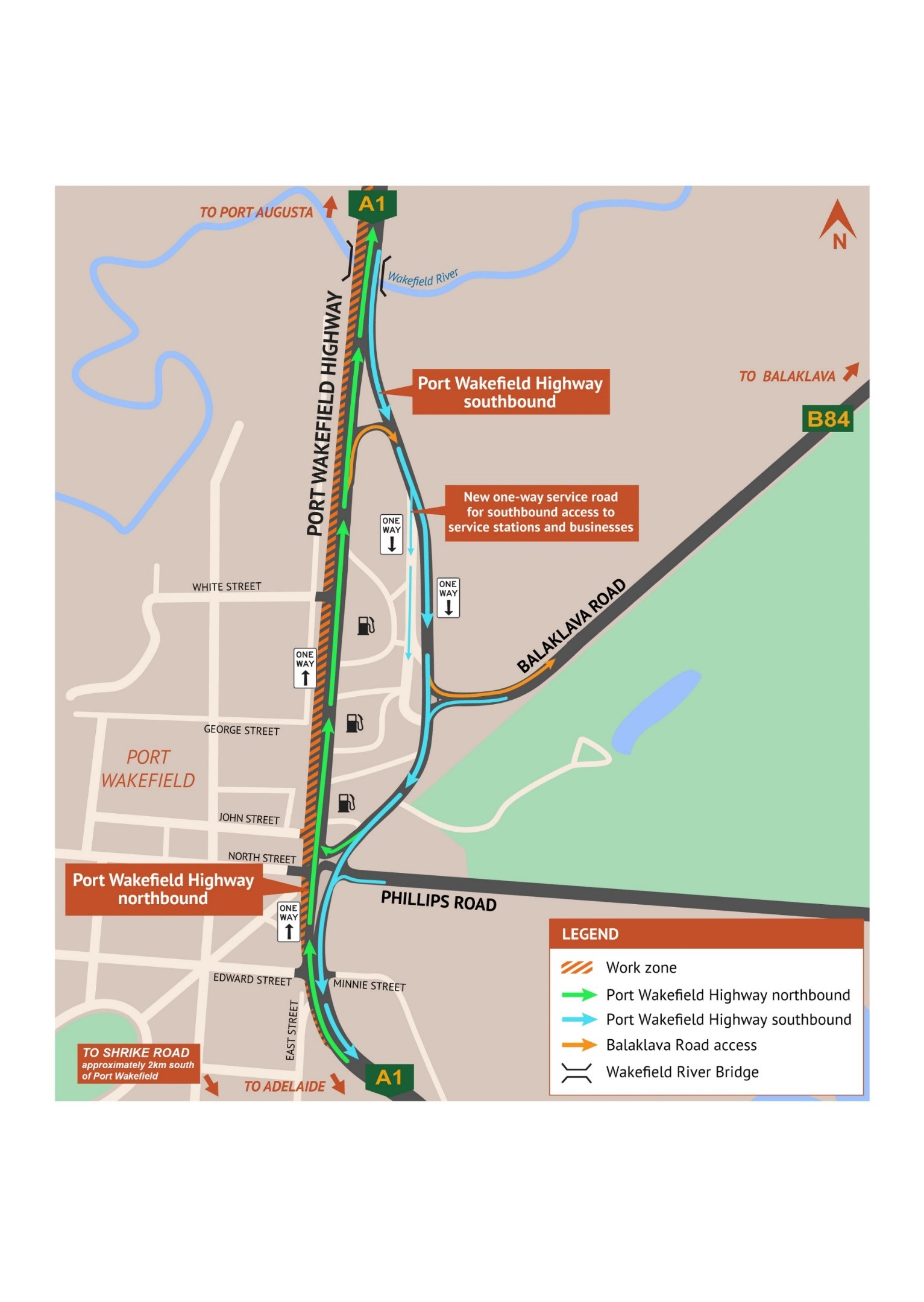
- For southbound traffic (towards Adelaide), two lanes will be open to traffic from south of the Wakefield River Bridge to Shrike Road to help reduce delays, as much as practically possible. Southbound traffic will need to use the new, recently opened one-way southbound road east of the service stations (see light blue arrows on the map below).
- A new, one-way service road has also opened for southbound traffic wishing to access the service stations and bakery (see light blue arrows on the map below). Motorists wanting to access businesses on the western side of Port Wakefield Highway will need to use dedicated U-turn facility just north of Phillips Road (see green arrows on the map below) and motorists wanting to access the town will continue to turn right at either Edward Street or East Street.
- For northbound traffic (towards Port Augusta), two lanes will be open to traffic between Shrike Road and the 24 Seven Port Wakefield (Liberty) service station to help reduce traffic delays, before being reduced to one lane through the current work zone (see green arrows on the map below).
- For motorists travelling northbound, access to Balaklava Road will be via the U-turn facility north of the township (see orange arrows on the map below).


